Well, knowing ziltch about GIS instead I've taken a detailed topo, overlain the scottish watershed route (Cape Wrath Variant) and the UK river map, and roughly marked out the route of the Watershed. Then I tidied it up a bit.
So, with the exception of the Scottish ending, this ought to be a half reasonable starting point for the actual geographic watershed. What a UK Divide route looks like may be quite considerably different though!
https://drive.google.com/file/d/0B05GvF ... sp=sharing
Uk Divide Route?
Moderators: Bearbonesnorm, Taylor, Chew
-
Bearbonesnorm

- Posts: 23943
- Joined: Sun Jun 05, 2011 8:53 pm
- Location: my own little world
Re: Uk Divide Route?
Shame about that down and back up section in the middle ... why can't these rivers behave themselves and go in straight lines? 
May the bridges you burn light your way
Re: Uk Divide Route?
Agreed, that's the (soon to be notorious) Avon Loop. I think there's a genuine argument for saying that no bike ride in history was ever improved by going to Coventry.Bearbonesnorm wrote:Shame about that down and back up section in the middle ... why can't these rivers behave themselves and go in straight lines?
Re: Uk Divide Route?
given that you are planning on finishing at dungeness, shouldn't you be starting at dounreay?Catbaiter wrote:Well, knowing ziltch about GIS instead I've taken a detailed topo, overlain the scottish watershed route (Cape Wrath Variant) and the UK river map, and roughly marked out the route of the Watershed. Then I tidied it up a bit.
So, with the exception of the Scottish ending, this ought to be a half reasonable starting point for the actual geographic watershed. What a UK Divide route looks like may be quite considerably different though!
https://drive.google.com/file/d/0B05GvF ... sp=sharing
and no, I'm not coming with you.
Re: Uk Divide Route?
Yes, you are.jam bo wrote:and no, I'm not coming with you.
Re: Uk Divide Route?
So here is the same watershed map with the HT550, Pennine Bridleway and South Downs marked on (bear in mind this is all super-rough). There are a lot of gaps, but I reckon is shows promise.
https://drive.google.com/file/d/0B05GvF ... sp=sharing
https://drive.google.com/file/d/0B05GvF ... sp=sharing

Re: Uk Divide Route?
Been following this and it all looks very interesting.
To answer questions relating to how pure the route needs to be, has any compared the TD with the actual watershed? I seem to recall that the TD route crosses the "divide" a dozen or so times, but I'd be interested to see if the route makes any notable omissions/ short cuts to the actual watershed.
To answer questions relating to how pure the route needs to be, has any compared the TD with the actual watershed? I seem to recall that the TD route crosses the "divide" a dozen or so times, but I'd be interested to see if the route makes any notable omissions/ short cuts to the actual watershed.
Re: Uk Divide Route?
I might be wrong, but I think this is a comparison of the two (the geographic divide being the thin black line).Ian wrote:Been following this and it all looks very interesting.
To answer questions relating to how pure the route needs to be, has any compared the TD with the actual watershed? I seem to recall that the TD route crosses the "divide" a dozen or so times, but I'd be interested to see if the route makes any notable omissions/ short cuts to the actual watershed.
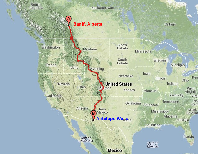
https://bikingthedivide2014.files.wordp ... rofile.png
Given the scale of that map, there are some pretty hefty divergences. Though that's not to undermine the guys who drew up the route!
EDIT: This is link for a zoomable version of the same map. I'm more sure the black line is the continental divide looking at it closely. https://eatsleepridegreatdivide.com/#start=0&end=2691. I think it's fair to say that there is definitely scope to go off-plan if the net result is better riding.
-
whitestone

- Posts: 7868
- Joined: Thu Dec 04, 2014 10:20 am
- Location: Skipton(ish)
- Contact:
Re: Uk Divide Route?
Doesn't the Tour Divide have to divert around some wilderness areas where cycling isn't allowed?
As close as is practical would be a starting point.
As close as is practical would be a starting point.
Better weight than wisdom, a traveller cannot carry
Re: Uk Divide Route?
It seems to. But there also seem to be areas where fairly dull looking tracks (which are very close to the geographic divide) have been sacrificed in favour of more interesting route selection.whitestone wrote:Doesn't the Tour Divide have to divert around some wilderness areas where cycling isn't allowed?
As close as is practical would be a starting point.
It begs the question; how pure is pure?
For example: If there is a horrible mud-plugging bridleway 2 miles from the UK Divide, and a stunning bit of singletrack 5 miles from the UK Divide, which gets picked for the route? The more geographically accurate one? Or the one which offers better biking?
IMO it would be the latter. But it has to be within reason... whatever the hell "reason" might be.

Re: Uk Divide Route?
If the south downs way is below the watershed and the north downs way is the bit above it that goes across to Dover, what's the watershed on?
Re: Uk Divide Route?
That's an excellent question, and I'll be the first to admit that the geomorphology of the SE isn't my strong suit.ctznsmith wrote:If the south downs way is below the watershed and the north downs way is the bit above it that goes across to Dover, what's the watershed on?
However if you go to the Geology viewer on the BGS website (http://mapapps.bgs.ac.uk/geologyofbritain/home.html), zoom in to the area in question, set the base map to National Geographic, play with the transparency a bit and ensure you click on "superficial only" you'll see that despite the fact that the North and South Downs are indeed higher ground, they are split in multiple locations by north/south tributaries to the Thames and to the English Channel respectively. The sources for these tributaries seems to be The Weald; another area of high ground sat halfway between the Downs. (You probably knew that already). I'm not sure why the Downs are cut through in this way, when there seems to be a perfectly reasonable route to the East, but in the absence of bothering to read up on the subject, I'll take the lazy route and blame geology and glaciation.
Bet you're glad you asked now aren't you?!
Re: Uk Divide Route?
Too far south for glaciation isn't it?
Anyhow back on the topic if you look at the Sustrans NCN maps you can take the 'downs link' south from Guildford to near Horsham and then if you can get across toward Crawley there is a bit of traffic free route that takes you through East Grinstead towards Royal Tonbridge Wells. Now that might be unpaved like the downs link or paved, I'll find out in the next couple of weeks and report back.
Then you need a route across the High Weald AONB and onto Dungeness.
Gettting to Guildford through that bit south of Reading 'may' be tricky due to MOD land.
Re: Uk Divide Route?
For the ice, yes. For the significant effects of meltwater and post-glacial Isostatic rebound, no.ctznsmith wrote:Too far south for glaciation isn't it?
Any info you can provide would be gratefully absorbed! Cheers.
Re: Uk Divide Route?
If you're referring to the bit through Forest Row and Hartfield, it's mainly hard packed gravel. Fine for a cx bike.ctznsmith wrote: there is a bit of traffic free route that takes you through East Grinstead towards Royal Tonbridge Wells. Now that might be unpaved like the downs link or paved, I'll find out in the next couple of weeks and report back.
You Tube:
https://www.youtube.com/channel/UCGYaFH ... mTPePCcCXQ
Instagram: https://www.instagram.com/dk.nwhy/
https://www.youtube.com/channel/UCGYaFH ... mTPePCcCXQ
Instagram: https://www.instagram.com/dk.nwhy/
Re: Uk Divide Route?
this document may provide some info on where the start and finish are 
http://epic.awi.de/29772/1/IHO1953a.pdf
http://epic.awi.de/29772/1/IHO1953a.pdf

Re: Uk Divide Route?
Yeah that's the bit I was thinking of.Dan_K wrote:If you're referring to the bit through Forest Row and Hartfield, it's mainly hard packed gravel. Fine for a cx bike.ctznsmith wrote: there is a bit of traffic free route that takes you through East Grinstead towards Royal Tonbridge Wells. Now that might be unpaved like the downs link or paved, I'll find out in the next couple of weeks and report back.
Re: Uk Divide Route?
Having spent several hours pouring through the OS Maps on Bing and the Sustrans maps a few things have become clear:
1. Yes, it's doable. BUT there are going to be quite a few on-road sections. I expect these will diminish the further north you go.
2. Using canal tow paths might help a bit http://www.jim-shead.com/waterways/CanalMap.gif http://www.waterscape.com/media/documents/22222.pdf. Especially if the route does the Avon Loop and where there are too many on-road sections (ie around Birmingham and the Shropshire Union Canal)
3. Despite prevailing winds, I'd suggest the route is a South to North job. Simply because if you're anything like me, you'll want to get the crapola bits and pieces South and Midlands sections out of the way before moving on to the better defined North and Scotland.
4. The south of this country is horribly overpopulated.
All of that being said. So far the start up to the Cotswolds is looking a bit like this (I suspect this may contentious). As ever I am completely open to alternatives and suggestions, I don't proclaim to know much about anything:
Option 1a:
1. Dungeness to Tunbridge Wells via the Rother Levels and Bedgebury Forest. This is mix of canal path, bridleway, road and woodland (need to check that the woodland is accessible)
2. Tunbridge to Crawley (on old railway line)
3. Crawley to Holmwood (road and bridleway)
4. Holmwood to Guildford through woods around Holmbury St Mary (this looks like well trodden MTB territory)
5. Guildford to Reading (somehow?!)
6. Kennet and Avon Canal to Devizes
7. Mid Wilts Way to Calne
8. Old Railway from Calne to Chippenham
9. On road from Chippenham to The Gibb, via Castle Combe (under M4)
10. Fosse Way non-stop to the Cotswold Airport (mostly restricted byway with some road).
Option 1b:
6. As above up to point 5 but keep going West from Guildford, not North to Reading, eventually meeting the Salisbury Plain and Devizes (clearly this needs work)
7. As point 7 (above)
Option 2:
1. Dungeness to Eastbourne (mostly road, probably on the coast)
2. South Downs Way to Winchester
3. Winchester to Andover (mostly bridleway)
4. Andover to Devizes via Salisbury Plain (needs work)
5. As Point 7 (Option 1)
I don't presume these are the only routes. Just the one's most obvious to me.

Re: Uk Divide Route?
Erm hmmmm! just to make a point....
I think you'll find the UK might start at either Hermaness or Saxavord on Unst ( where I am just now ) There is a watershed down the 'spine' of Shetland, though you'd be a better bike pusher/carrier than me to do it strictly!
Then Orkney to Scrabster before you decide your mainland UK starting point, Duncansby Head being the closest.
Don't mind me, carry on...
I think you'll find the UK might start at either Hermaness or Saxavord on Unst ( where I am just now
Then Orkney to Scrabster before you decide your mainland UK starting point, Duncansby Head being the closest.
Don't mind me, carry on...
Re: Uk Divide Route?
Apologies. Please assume that there's a silent "mainland" attached to the route name!Moder-dye wrote:Erm hmmmm! just to make a point....
I think you'll find the UK might start at either Hermaness or Saxavord on Unst ( where I am just now
Then Orkney to Scrabster before you decide your mainland UK starting point, Duncansby Head being the closest.
Don't mind me, carry on...
Re: Uk Divide Route?
There always is
-
Dave Barter

- Posts: 3611
- Joined: Sun Jun 16, 2013 6:21 pm
Re: Uk Divide Route?
6. Kennet and Avon Canal to Devizes
That section is cheeky isn't it? I thought you had to go on the road from Kintbury to Devises
That section is cheeky isn't it? I thought you had to go on the road from Kintbury to Devises
Elite keyboard warrior, DNF'er, Swearer
Re: Uk Divide Route?
Good to know, thanks! It looks like you can jump onto the White Horse Way from just north of Burbage at Burbage Wharf. Between Kintbury and Burbage Wharf there looks to be a load of lanes and restricted byways which should make the route interesting.Dave Barter wrote:6. Kennet and Avon Canal to Devizes
That section is cheeky isn't it? I thought you had to go on the road from Kintbury to Devises
Re: Uk Divide Route?
I tend to avoid it as there's much better riding up on the downs, but I've ridden bits of the Tunbridge/forest row/crawley stuff in the past. I'll try and remember to have a look at the routes I've used and let you know what's good- there are some quite pretty bits around there.
Some of the flat ground between Crawley and the Surrey hills has been known to get pretty boggy in the wrong conditions so might not be fun- once you hit the Leith/holmbury/pitch run there's a nice few miles of sandy riding with plenty of singletrack in the woods. Then blackheath to Guilford.
Some of the flat ground between Crawley and the Surrey hills has been known to get pretty boggy in the wrong conditions so might not be fun- once you hit the Leith/holmbury/pitch run there's a nice few miles of sandy riding with plenty of singletrack in the woods. Then blackheath to Guilford.
Re: Uk Divide Route?
Also Guildford to reading takes you through the swinley area and surroundings. There are a good number of tracks and trails round there but I don't know them well enough to piece together a route- I think some of the army land has become more contentious lately so it may need an up to date local. That area on my Google maps is littered with xc race start locations though