
The Middle. Lamb Hill Bothy.

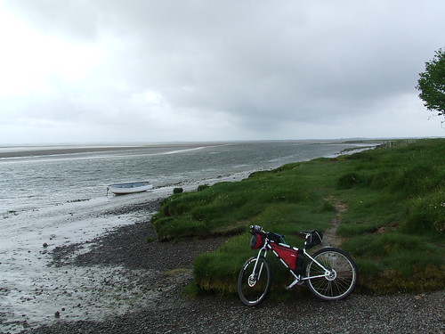
The End. The Tweed Estuary from Spittal.
I really must sort out a chest harness for my camera as carrying it in my bum bag means I don't take enough pictures due to the hassle of getting it out and putting it away again. On the WRT I used my 5 mega pixel phone camera but reflection from the screen made it impossible to frame pictures and I was less than impressed with the quality of the pictures.
Overall I was out for four days/three nights, rode 219 miles, cycled for 26h42m at an average moving speed 8.2 mph. For the actual ride itself I set off at 10 am saturday and arrived at Spittal at 5.30 pm sunday so not a startling completion time and i'll be the first to admit that I missed out a part of the route.
I decided to ride to the start as I wanted to check out some trails to see if they actually existed on the ground with a view to a 250 mile route for next year and wanted to take full advantage of the fact that my wife was away visiting her daughter.
Day 1 was 44 miles, 50/50 road/off road in hot sunny weather. I bivi'd in the Cheviot Hills near Alwinton and was glad of the breeze up there as midge activity elsewhere was horrendous. My site was a few miles north of Warcop military training grounds and no sooner had I set up and started cooking a helicopter appeared and started circling and shooting rockets. Then they started dropping flares and a heavy machine gun opened up, what a racket those things make. This went on for a couple of hours but stopped at 10.30pm so I managed a good nights sleep. In the morning as I was packing up the shepherd turned up on his quad checking on his sheep. He didn't bat an eye at my presence despite me being in England so actually camping ilegally and gave me a nod as he drove past.
Day 2 was 56 miles, 50/50 road/off road and again in hot sunny weather. I climbed up onto the Cheviot ridge then dropped into Byrness followed by another climb to Blakehope Nick before dropping to Kielder village where I had lunch in the pub and had a nice chat with a guy who works at Kielder bike shop. Next came about 20 miles riding along a dissused railway line that took me from Kielder to near Newcastleton. Most of this was easy going but there where some boggy but rideable bits through cuttings and the scenery was lovely. My bivi spot that night was not great as it was very windy and I wished I set up at a spot i'd seen earlier nearer to Gretna but the chance of being discovered their would have been very high and I was worried that my bike might have been stolen as I slept.
Day 3, the start of The Solstice Ride. 60 miles ridden, 18 on road, 32 forest road, 10 off road. The weather was overcast and I had regular heavy rain showers throughout the day but the prevailing westerly wind helped push me along. On the first bit of forest road as I neared Kershope Burn I heard the distinct sound of a very souped up car engine and within a few minutes came across some marshalls. They where very friendly as they explained that the RAC Rally was happening in Kielder Forest today! Bugger I thought, that's me knackered then. They then went on to explain that the car I had heard was the last one through this morning and they where now on a lunch break for the next hour and a half when it would start again. They asked me my route and showed me the rally route, our routes coincided for about four miles. They where fine about me continuing as long as I was off the route when it restarted. It felt very strange cycling along with lots of rally spectators following my progress.
As I started to descend to Kielder village the heavens literally opened and it poured down for half an hour, I was dripping as I entered the pub for the second time in two days for lunch. Much fortified I set off again to climb up to Blakehope Nick then descend to Byrness. I had to detour on the climb onto the Cheviot ridge because of forestry work going on. Their sign said to take the bridleway all the way to the top but I knew from experience that this path does not exist on the ground due to being totally overgrown. I checked the map and took the Borders County Ride route to the top. I was starting to suffer at this point after 50 miles of riding and now had to face 10 miles of moorland singletrack to Lamb Hill bothy, the point i'd promised myself i'd reach today. It was whilst riding this last ten miles that I started to realize how much determination a proper long distance bikepack racer must have to do what they do, your mind and body must be constantly screaming "stop" but you carry on for hour after hour, I have nothing but total admiration for you all. It was also on this last stretch where I had a slow speed fall that scuppered my plan to do the complete route. About two miles from the bothy there is a stone slab path that is very slippery when wet. Due to tiredness and lack of concentration I grabbed too much front brake and went straight down hitting my left knee hard on the unforgiving rock. I cycled the last couple of miles slowly and in great pain, the sight of the bothy coming into view cheered me no end. A older guy called Jim had a tent set up by the bothy as the bench seats in the bothy aren't very wide so not the best for sleeping on. After eating and a wee dram of whisky I hit the sack about 10pm. I had set my alarm for 6am but when it went off I fell back asleep and didn't wake again untill 9.30!!!
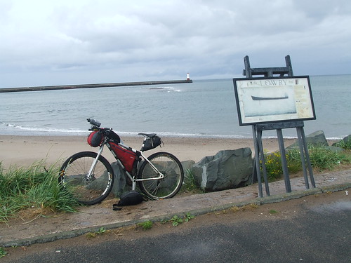
Day 4, 58 miles ridden, 28 miles off road, 30 miles on road. After cursing myself for sleeping so late I got up and realized my knee was still giving me some pain. I had something to eat and took some paracetemol and set off. The weather was the same as yesterday, lots of heavy rain showers but the wind was mostly in my favour. As I continued along the ridgeline my knee started to give me more pain especially on the climbs. As I dropped into Ingram valley it was decision time, carry along on the route knowing that the next 15 miles would be the hardest part of the whole route with three climbs and some bike hike or take an easier bridleway/road route to Wooler. I decided on the latter and am glad I did as the easier going was much kinder on my knee. From Wooler I was counting the miles down to the end. As I turned north to follow the coastline from Holy Island the wind changed direction and blew straight into my face all the way to the end, typical. I arrived at 5.30pm.
The first time I did this route I did it over three days and was much happier with doing it over that time. I have realized that after 45 miles or so I start to not enjoy the riding, it's not that I couldn't physically ride more because I could but am happier not to. This again brings home to me how much you real racers out there put up with, I just cannot comprehend just how much you must go through in order to do what you do, well done to you all.

