Page 11 of 34
Re: Veloviewer map - explorer tiles
Posted: Thu Dec 27, 2018 10:46 am
by Chew
A ride out over the past few days to collect one square (and a few more) to link my main cluster to my Dales one
Before:
After:
Working on expanding my cluster until we get some hard frosts, so start to fill on some of the gaps
Cluster now up to 954
Re: Veloviewer map - explorer tiles
Posted: Fri Dec 28, 2018 2:52 pm
by Blackhound
Got out today for first ride in a week and last of the year. Made it to 15x15 for the year which looking at the table for 2018 puts me in 28th place out of over 64,000 peeps.
Will try to get a similar score next year and try and add 3or 4 squares to my lifetime score.
Re: Veloviewer map - explorer tiles
Posted: Fri Dec 28, 2018 7:31 pm
by belugabob
Starting from an 8x8 state, I popped out - yesterday - to fill in some gaps at one edge, with the intention of it being preparation for another ride to extend the other edge.
Accidentally progressed to 9x9 - but, surprisingly, not including the original 8x8.
Also managed to ride completely round two tiles, as I'd paid more attention to avoiding busy roads than where the tiles were - doh!
Hoping to get to 11x11 by the end of the year.
It's all quite sad (in a trainspotting kind of way) but it keeps me off the streets - err, hang on a minute.

Re: Veloviewer map - explorer tiles
Posted: Wed Jan 02, 2019 8:46 pm
by belugabob
Not quite the end of the year, but I popped out for a 38 mile road ride, yesterday, to get to 11x11 - turned out to be a 46 mile rile, thanks to a fairly short connecting road being closed and the diversion being a long way round. It was a great day to be out, though, so the extra miles weren't a great burden (even if they didn't result in any extra tiles)
This tile-bagging lark is a great incentive to do more exploring, isn't it?
Re: Veloviewer map - explorer tiles
Posted: Sat Jan 05, 2019 5:23 pm
by Chew
First person to get to 100x100 squares
https://rideeverytile.com/2019/01/05/th ... g-century/
Think I can just about squeeze that size in between the Mersey and Humber, but it’s going to take some time....
Re: Veloviewer map - explorer tiles
Posted: Mon Jan 14, 2019 9:24 am
by chris n
Got my Explorer score to 17x17 and finally shifted my max cluster down to where I live now
I think I can extend the cluster across the Severn with a bit of cheeky footpath but any increases to the max square will need to be to the south and east. A few more rides between Bristol and Corsham should get me to 20x20 fairly quickly.
Re: Veloviewer map - explorer tiles
Posted: Mon Jan 14, 2019 12:27 pm
by belugabob
Nice work!
Re: Veloviewer map - explorer tiles
Posted: Mon Jan 14, 2019 1:58 pm
by Richard G
Annoyingly I didn't get a single one on this weekends BB event. Next time I'll make the route and get a bunch... though probably with significantly more deathmarch.
Re: Veloviewer map - explorer tiles
Posted: Mon Jan 14, 2019 2:14 pm
by benp1
That century is ridiculous. Zoomed into my local home turf and the lines don't look quite right, probably to do with the way it was recorded - I'm not saying he didn't do it
That is a stellar effort
Re: Veloviewer map - explorer tiles
Posted: Mon Jan 14, 2019 3:12 pm
by whitestone
I got about 25 new squares over the weekend

I might just have planned a route around them

Ben - Veloviewer saves time and space by using an abbreviated version of longer Strava activies so if you are following a roughly straight track it will only use the start and end points. If you open up the activity through VV then it downloads the full version and marks up the squares accordingly but on the activity map it still shows the abbreviated version. Sometimes you think you've got a square so open it up only to find that you get that one but lose another!
Re: Veloviewer map - explorer tiles
Posted: Mon Jan 14, 2019 4:50 pm
by benp1
whitestone wrote:
Ben - Veloviewer saves time and space by using an abbreviated version of longer Strava activies so if you are following a roughly straight track it will only use the start and end points. If you open up the activity through VV then it downloads the full version and marks up the squares accordingly but on the activity map it still shows the abbreviated version. Sometimes you think you've got a square so open it up only to find that you get that one but lose another!
Ah, didn't know that, thanks Bob. I did try to open one of his activities, as a couple looked interesting, but VV wasn't playing ball so I gave up.
Re: Veloviewer map - explorer tiles
Posted: Mon Feb 18, 2019 2:40 pm
by Chew
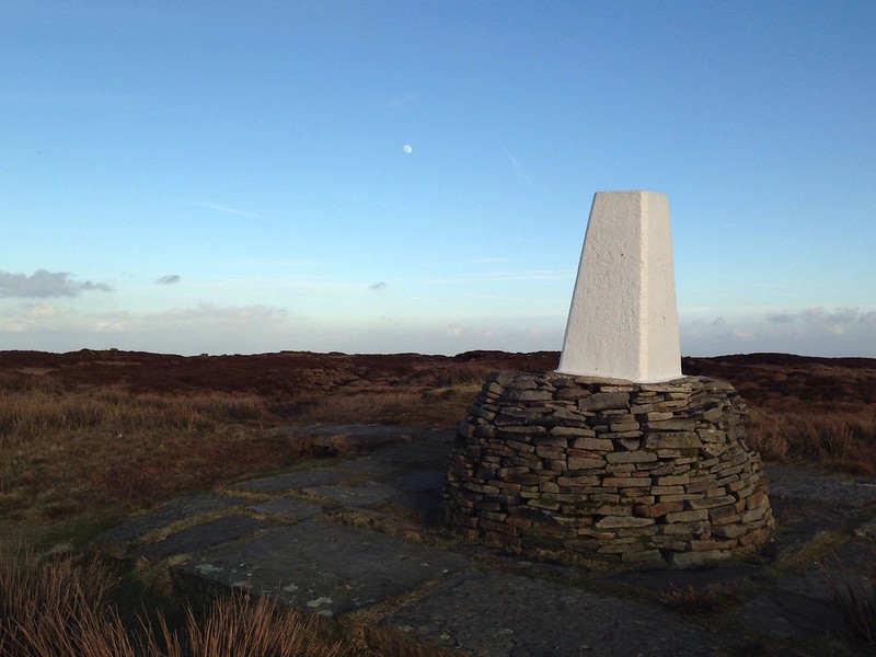
Made the most of the summer conditions yesterday, to pick up one of the non-rideable squares local to me, with a moorland walk up to Dean Head Hill.
A lot drier and less tussocky than it could have been.
More aiming to expand my cluster this year, rather than my max square, which is now up to 966
Re: Veloviewer map - explorer tiles
Posted: Mon Feb 18, 2019 4:04 pm
by In Reverse
Is that the Black Hill trig point Chew? Heading up there tomorrow on the bike for exactly the same reason. Going to HaB up from the A635 across Dean Head Hill on the footpath to get that square, then do the long descent past Laddow Rocks into Crowden.
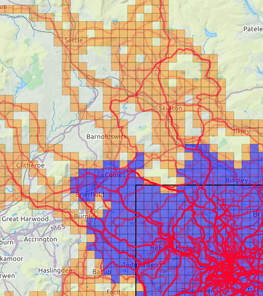
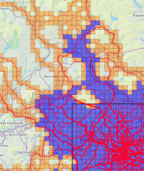
Got up on Dog Hill on saturday, was surprisingly rideable. Filled in a patch on my cluster to go from this

to this

Max square now at 22, I've got some grim rides/walks to push east into the bits of the Peaks I haven't covered.
Re: Veloviewer map - explorer tiles
Posted: Mon Feb 18, 2019 7:55 pm
by Chew
In Reverse wrote:Is that the Black Hill trig point Chew? Heading up there tomorrow on the bike for exactly the same reason. Going to HaB up from the A635 across Dean Head Hill on the footpath to get that square, then do the long descent past Laddow Rocks into Crowden.
Yes
I walked up from 031063 to Black Hill and then north on the Pennine Way to the A635
I've also 'ridden' south on the Pennine Way to Black Hill and then continued south to 056015 before cutting west to Chew Reservoir and back down to Greenfield.
Its quite dry up there at the moment, so a great time to do it.
Will be good to see how someone else tackles those squares north of of Woodhead road.
Have fun
Re: Veloviewer map - explorer tiles
Posted: Mon Feb 18, 2019 10:21 pm
by benp1
Andy, what program are you using there? I don't recognise it
Re: Veloviewer map - explorer tiles
Posted: Mon Feb 18, 2019 11:08 pm
by ScotRoutes
benp1 wrote:Andy, what program are you using there? I don't recognise it
That's screenshots from an mobile phone app called Explorer Helper
Re: Veloviewer map - explorer tiles
Posted: Mon Feb 18, 2019 11:11 pm
by In Reverse
It's "Explorer Helper for Veloviewer" Ben. Android app off the Play Store. It's really good.
Edit: as previously recommended by ScotRoutes ^^

Re: Veloviewer map - explorer tiles
Posted: Tue Feb 19, 2019 12:21 am
by redefined_cycles
How cool is this... just noticed the thread and didnt know one can play such an epic game im veliviewer... How can I ensure my recorded rides will make it onto the game (is that what we calls it??)...
Thanks in advance kindly... and hello
Shafiq
Re: Veloviewer map - explorer tiles
Posted: Tue Feb 19, 2019 1:15 am
by ScotRoutes
redefined_cycles wrote:How cool is this... just noticed the thread and didnt know one can play such an epic game im veliviewer... How can I ensure my recorded rides will make it onto the game (is that what we calls it??)...
Thanks in advance kindly... and hello
Shafiq
If it's on Strava then VeloViewer will pick up your rides/walks/runs/paddles automatically. I think you need to subscribe for the full package but there are lots of other geeky stats in there too.

Re: Veloviewer map - explorer tiles
Posted: Tue Feb 19, 2019 1:56 am
by redefined_cycles
Aha... Thanks Scot. Will see about subsribing and get back here with how far my maps been built. Road biking might not be boring for much longer afterall...
Re: Veloviewer map - explorer tiles
Posted: Tue Feb 19, 2019 3:33 am
by redefined_cycles
(Oh what an absolute pain inserting a pic is)..

Anyway. So looking at my (free version) pic above.. the darker squares mean what as opposed to the lighter shaded squares??
Also if I zoom out it doesn't show the activities in and around birmingham or Bristolia/South West. Is that cos they are not linked to my other squares or is it just cos I'm on free version...
Re: Veloviewer map - explorer tiles
Posted: Tue Feb 19, 2019 6:47 am
by Dyffers
Doesn't the free version only allow your last 25 rides?
Bung Ben VeloViewer a tenner for the full version, it's well worth it.
Re: Veloviewer map - explorer tiles
Posted: Tue Feb 19, 2019 7:05 am
by whitestone
Yes, the free version is just 25 rides.
The darker squares are your max cluster squares, which are those contiguous squares not bordering an unvisited square. The lighter squares are the remaining squares you've visited.
There's a thread about inserting images. Always much easier from a desktop than mobile.
Re: Veloviewer map - explorer tiles
Posted: Tue Feb 19, 2019 8:03 am
by redefined_cycles
All sorted... been on a quoet night shift so had chance to purchase the subscription after reading about the darker and lihhter squares... Is there a BB league table showing who's ahead...
if not maybe we should open one up??

I'm on 12
Re: Veloviewer map - explorer tiles
Posted: Tue Feb 19, 2019 9:10 am
by ScotRoutes
Have you joined the Bearbones Bikepacking club on Strava? If you've done that, the have a look at your Summary page on Veloviewer, then click on "Overall/Club Yearly Leaderboards".
Then the "Clubs" tab.
Then choose Bearbones Bikepacking in the drop-down menu.
I think the default order is Distance but there are many sorting options, including Explorer Square and Explorer Cluster.
Oh - and welcome to the game!