Is it specifcally along the cyclepath below the tarmac road
Yes, it's a busy bit of road so the cycleway it is.
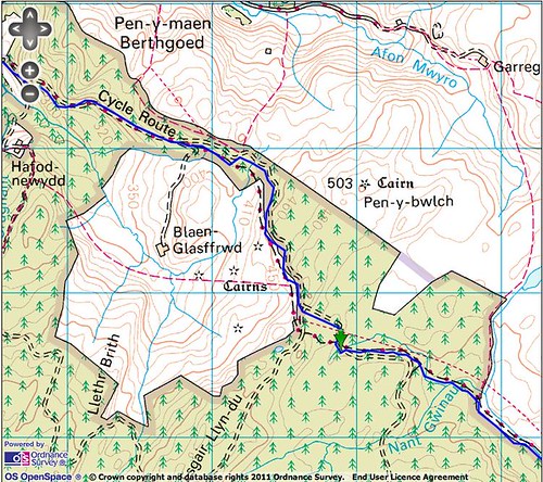
Similarly, the climb after Strata Florida - are you intending for people to ride the byway or the fireroad?
The first section into the forest I've put on the fireroad as the byway is a bit of a pointless slog. The route then goes onto the byway at the top of the initial climb.
The route then goes onto the byway at the top of the initial climb.
Not sure what you mean by initial bit, as I didn't really notice a slackening gradient when I last rode it :?
Fireroad up to 779626 (green arrow in pic) and then byway? Twyi Climb by ianbarrington, on Flickr
I'm sure Stu means, take the first land rover track as you leave the car park at the start of the climb (avoiding the inital fire road), and then pick up the fire road later on.
From the green arrow you'll need to take the track to start on the first section of the water splashes. You can pick it up further down, from the fire road, but its easy to miss the turning (past experiece from WRT'10). Sure Stu would be sending us that way.
Its a nice section, but it would be nice not to get wet at that stage of the day. Wondering if its just a coincidence thats theres Moel Prysgau Bothie at the bottom at 100kish???? Seems a bit pointless going down there as we have to climb back up straight afterards.
Chew ... stick to the fireroad all the way out of the carpark until you reach Ians green arrow ... then pick up the byway there. Obviously it means climbing on fireroad rather than 'off road' but the idea is, it'll save some energy for later The route doesn't go as far as the bothy but obviously a detour is more than 'legal' so long as you return back to your departure point to restart the route.
No one will be penalised if they choose to use the byway rather than the fireroad though ... hey, like I'll even know.
Help... ...Help... ... I have spent three days trying to print out the map route using getamap!!! I have even called them to try and get some help.......I have to say they where pretty poor.....I have the route on my GPS, but its an old one and therefore no O/S mapping....I would not start without a backup of the route on a paper map!!!
Is there any way someone could print me a copy so I can get back to packing my bike??? or please let me in on the secret to printing?????? Its driving me mad!!!!
Really looking forward to the event........
If it's any help, I used bikehike and took a series of screen shots (with the OS map toggled to the large window). Pasted and cropped in MS Paint, printed those out, worked a treat. Bit of work but very happy with results.
:) Happy now......Memory map used!!! Managed to download the route from my GPS and print off!! Thank you, gentlemen for your kind help! Now all I have to do is make my frame bag from my Pugsley, fit my Paragon!!! Just too big......See you all on Saturday morning!! Jane and I cannot wait!!!!
Instead of a refunding me for pulling out can the organisers put the money in the air ambulance chairity box please.
Ref mm-on-point
mattrogueagent@hotmail
Thanks