Hi there.
I wondered if someone could take a picture of their 1030 plus showing what information the maps show when in the hills? I'm struggling to find mapping pictures that are not road oriented.
Thanks :)
Garmin 1030 Plus Mapping Question
Moderators: Bearbonesnorm, Taylor, Chew
-
Escape Goat

- Posts: 2603
- Joined: Thu Nov 01, 2018 10:41 pm
- Location: Not nearly close enough to Scotland...
Garmin 1030 Plus Mapping Question
 My Movie Channel: https://tinyurl.com/YoutubeEG
  My Instagram: https://www.instagram.com/allen.boardman
Re: Garmin 1030 Plus Mapping Question
What do you mean exactly? I have an 810, which I would imagine would be pretty much the same... but the mapping is just a standard OS map with a little triangle showing your position and a line showing your route... like the main picture here: https://road.cc/content/review/100530-g ... ail-bundle
What more info do you want? Happy to take a photo of my 810 showing something if that helps....
What more info do you want? Happy to take a photo of my 810 showing something if that helps....
-
lune ranger
- Posts: 2380
- Joined: Thu Dec 15, 2016 7:52 pm
- Location: Peoples Republic of Devon
Re: Garmin 1030 Plus Mapping Question
A further point would be that it depends on the map you have loaded onto the device.
I don’t use OS on my Edge or Etrex because i find it way too busy on such a small screen. As I usually have a Route loaded rather than a Track I find the cheap Garmin osm based naps perfectly adequate both for both on and off road.
I don’t use OS on my Edge or Etrex because i find it way too busy on such a small screen. As I usually have a Route loaded rather than a Track I find the cheap Garmin osm based naps perfectly adequate both for both on and off road.
If you are going through hell, keep going.
WSC
WSC
-
Escape Goat
- Posts: 2603
- Joined: Thu Nov 01, 2018 10:41 pm
- Location: Not nearly close enough to Scotland...
Re: Garmin 1030 Plus Mapping Question
So this is my wahoo just out of Wasdale, heading over towards Eskdale Moor. Very limited.

I can't scroll around and I can't see if there is other routes available other than this one.
When I zoom out on wahoo, the small tracks thst may show, dissappear and then I can't scroll around.
I wondered if anyone had a picture of their garmin 1030 base map in the same sort of environment so see what data is shown, I.e. Are tracks shown enough to be able to plan your way across or around something?
My Movie Channel: https://tinyurl.com/YoutubeEG My Instagram: https://www.instagram.com/allen.boardman-
lune ranger
- Posts: 2380
- Joined: Thu Dec 15, 2016 7:52 pm
- Location: Peoples Republic of Devon
Re: Garmin 1030 Plus Mapping Question
Fair point.
The map scale/zoom is adjustable on n30 series Edge computers so in theory you can see as much or as little as you want.
IME it’s still nowhere near as good as a paper map for charging route on the fly.
The map scale/zoom is adjustable on n30 series Edge computers so in theory you can see as much or as little as you want.
IME it’s still nowhere near as good as a paper map for charging route on the fly.
If you are going through hell, keep going.
WSC
WSC
Re: Garmin 1030 Plus Mapping Question
The pre-loaded maps on a Garmin 1030 are Garmin branded OSM data.
Garmin adds some extra detail.
These maps are plenty for following a GPX route.
I also have the Garmin branded OS maps.
As mentioned, there is a lot of detail on a small screen.
However, a recent firmware upgrade for the 1030 made the line thicker when in navigation mode, and added direction arrows.
Sound a little change, works well.
For an event such as bb200, where one is following the line verbatim, the pre-installed maps are fine.
For a bb200 it would be useful to have an offline copy of the aerial photography on the device (Garmin calls this Birdseye), then, at 2am in the morning, when one can’t see the track, one could turn on the aerial photography overlay to see that, ah, the track is 10metres to the right.

Such a feature is free and included on the 66i (direct to device I believe Garmin calls it)
Did suggest to ViewRanger the ability to download the aerial photography on a range either side of a GPX.
Garmin adds some extra detail.
These maps are plenty for following a GPX route.
I also have the Garmin branded OS maps.
As mentioned, there is a lot of detail on a small screen.
However, a recent firmware upgrade for the 1030 made the line thicker when in navigation mode, and added direction arrows.
Sound a little change, works well.
For an event such as bb200, where one is following the line verbatim, the pre-installed maps are fine.
For a bb200 it would be useful to have an offline copy of the aerial photography on the device (Garmin calls this Birdseye), then, at 2am in the morning, when one can’t see the track, one could turn on the aerial photography overlay to see that, ah, the track is 10metres to the right.


Such a feature is free and included on the 66i (direct to device I believe Garmin calls it)
Did suggest to ViewRanger the ability to download the aerial photography on a range either side of a GPX.
-
ScotRoutes
- Posts: 8144
- Joined: Mon Mar 18, 2013 9:56 am
Re: Garmin 1030 Plus Mapping Question
I see the bb200 GPX as a suggested direction.ScotRoutes wrote: ↑Sat Aug 14, 2021 2:02 pmI've still not forgiven Stu for the lack of accuracy on the supplied BB200 route for exactly this reason
then spend the week prior to the bb200 "correcting" the GPX in viewranger
still catches me out, just not as badly
-
ScotRoutes
- Posts: 8144
- Joined: Mon Mar 18, 2013 9:56 am
Re: Garmin 1030 Plus Mapping Question
I think part of my concern/anxiety was being somewhat unfamiliar with the arcane access laws and therefore assuming I had to stick to the GPX track. For the Cairngorms Loop, I've tried to make it clear where the track MUST be followed and which parts have alternative (though nearby) options. I guess that the two (CL300- and BB200) are different though in that the CL300 is a fixed route and so attracts a few folk going for a good time, necessitating clarity for comparison.
Re: Garmin 1030 Plus Mapping Question
to be fair, the track is never far off.ScotRoutes wrote: ↑Sat Aug 14, 2021 2:22 pm I think part of my concern/anxiety was being somewhat unfamiliar with the arcane access laws and therefore assuming I had to stick to the GPX track. For the Cairngorms Loop, I've tried to make it clear where the track MUST be followed and which parts have alternative (though nearby) options. I guess that the two (CL300- and BB200) are different though in that the CL300 is a fixed route and so attracts a few folk going for a good time, necessitating clarity for comparison.
a section near the end of 2018 (well, think it was 2018, it's a fog at the back of my mind)
stu was apparently going to send us back down the road to the finish
dee apparently thought that was too easy, so suggested an alternative route
now, whilst the tracking seemingly existed on aerial when i checked later, finding said track at 4am proved bl00dy impossible.
ended up using a valley as a handrail, to a wall as a catch feature, then used that wall as a second handrail.
lots of swearing.
all part of the fun
-
Bearbonesnorm

- Posts: 23937
- Joined: Sun Jun 05, 2011 8:53 pm
- Location: my own little world
Re: Garmin 1030 Plus Mapping Question
RE BB200 - the route will follow the line of the RoW indicated on the map. However, whether that RoW actually exists on the ground is a different thing entirely. It's not done to (a) catch people out or (b) because I'm a bastard, it's simply a matter of trying to keep things above board and reduce the potential for conflict with landowners, other users, etc. There will be times when a sheep path or similar might exist nearby and run parallel - I certainly wouldn't blame anyone for using such a thing.
I believe the final section of 2018 caught folk out because things had seemed quite straightforward and almost pleasant until that point
I believe the final section of 2018 caught folk out because things had seemed quite straightforward and almost pleasant until that point
May the bridges you burn light your way
Re: Garmin 1030 Plus Mapping Question
if we wanted easy we'd ride a sportive, on the road, during the day, in summer, in the dry.Bearbonesnorm wrote: ↑Sat Aug 14, 2021 3:59 pm RE BB200 - the route will follow the line of the RoW indicated on the map. However, whether that RoW actually exists on the ground is a different thing entirely. It's not done to (a) catch people out or (b) because I'm a bastard, it's simply a matter of trying to keep things above board and reduce the potential for conflict with landowners, other users, etc. There will be times when a sheep path or similar might exist nearby and run parallel - I certainly wouldn't blame anyone for using such a thing.
I believe the final section of 2018 caught folk out because things had seemed quite straightforward and almost pleasant until that point
2019 anyone?
bb200 is exactly as it describes on the tin.
and long may it remain thus
-
Escape Goat
- Posts: 2603
- Joined: Thu Nov 01, 2018 10:41 pm
- Location: Not nearly close enough to Scotland...
Re: Garmin 1030 Plus Mapping Question
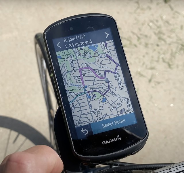
I finally found a decent picture - the 1030 plus is usable with Trail forks, so loads of info...
 [/url]
[/url] My Movie Channel: https://tinyurl.com/YoutubeEG My Instagram: https://www.instagram.com/allen.boardman
Re: Garmin 1030 Plus Mapping Question
Remember, you can load different maps onto a bunch of Edges (surely 8XX and 10XX). And swap inbetween them on the go, say when crossing a boarder. My 820 shows a very, very similar map to the one above.Escape Goat wrote: ↑Sun Aug 15, 2021 12:01 pm I finally found a decent picture - the 1030 plus is usable with Trail forks, so loads of info...
Even my Fenix has a map (pre-installed) that looks like that.
Whilst I don't know Wahoo devices, I can't imagine them (at least the more fancy models) to not come with a map or display a (eg OSM) map of your choice.
Re: Garmin 1030 Plus Mapping Question
Hmmm... can't get my head around thinking... well...Escape Goat wrote: ↑Thu Aug 12, 2021 10:17 pm So this is my wahoo just out of Wasdale, heading over towards Eskdale Moor. Very limited.
I can't scroll around and I can't see if there is other routes available other than this one.
When I zoom out on wahoo, the small tracks thst may show, dissappear and then I can't scroll around.
I wondered if anyone had a picture of their garmin 1030 base map in the same sort of environment so see what data is shown, I.e. Are tracks shown enough to be able to plan your way across or around something?
Two issues.
1. No map. Since I don't know Wahoo units, which one's can/can't display maps, types of maps etc. I can't help here, but surely someone who can will chime in.
2. Settings. Depending on zoom level my Edge shows me more or less details. This is adjustable in the map settings on the device. Wahoo clearly must have such settings too.
-
Escape Goat
- Posts: 2603
- Joined: Thu Nov 01, 2018 10:41 pm
- Location: Not nearly close enough to Scotland...
Re: Garmin 1030 Plus Mapping Question
The wahoo shows you more detail if you zoom in, if you zoom out, you get to see main roads or place names. There's no settings to change this. You also can't browse around the area.
As far as maps wahoo have a basic map on. Easy for cities etc. Off road it's OK > sometimes unusable.
As far as maps wahoo have a basic map on. Easy for cities etc. Off road it's OK > sometimes unusable.
My Movie Channel: https://tinyurl.com/YoutubeEG My Instagram: https://www.instagram.com/allen.boardmanRe: Garmin 1030 Plus Mapping Question
Wow, that's cr*p. I hope you got it for free
What Wahoo model?
What Wahoo model?
-
Escape Goat
- Posts: 2603
- Joined: Thu Nov 01, 2018 10:41 pm
- Location: Not nearly close enough to Scotland...
Re: Garmin 1030 Plus Mapping Question
Well I didn't pay rrp :)
Its the roam. But they all do that.
Its the roam. But they all do that.
My Movie Channel: https://tinyurl.com/YoutubeEG My Instagram: https://www.instagram.com/allen.boardman