Page 1 of 1
What Going On With The Track Taken From The Highlands;
Posted: Sat Aug 22, 2020 10:29 pm
by Escape Goat
Hi
There's a few routes that share the same tracks, though An Turas Mor skirts around a loch with no visible track;

It looks like a boat is needed here;

This claims its a causeway, is it really?
EDIT: Wrong picture uploaded for causeway
 EDIT; Should have been this one which has been confirmed as a causeway. Apologies.

Any local knowledge or help will be greatly appreciated.
Thanks
Re: What Going On With The Track Taken From The Highlands;
Posted: Sat Aug 22, 2020 10:43 pm
by fatbikephil
The track round Loch Dionard isn't - its a fairly tricky hike a bike which doesn't quite make deathmarch status. The crossing of the river at the south eastern end can be tricky....
Second and third pic is the famous crossing of the Strath na sealga on the Highland Trail route. There ain't no causeway.....
Re: What Going On With The Track Taken From The Highlands;
Posted: Sun Aug 23, 2020 7:52 am
by Escape Goat
Thanks. Back to the drawing board.
Re: What Going On With The Track Taken From The Highlands;
Posted: Sun Aug 23, 2020 8:35 am
by NewRetroTom
I can confirm, having fished loch Dionard (from a boat) that there are no tracks around it.
The Gualin estate who own it also used to be funny about bikes using the track that goes up the strath to the loch. Don't know if that's still the case or if they now understand how land access laws work!
Re: What Going On With The Track Taken From The Highlands;
Posted: Sun Aug 23, 2020 9:06 am
by sean_iow
Escape Goat wrote: ↑Sun Aug 23, 2020 7:52 am
Thanks. Back to the drawing board.
Don't be put off by a lack of track or causeway. If it's on a published route that's been ridden then it's passable.
On the HT550 there's a bit round a loch (forgotten the name) late on the first or early on the second day - it goes past the haunted house. It's a pain pushing and carrying the bike over the rocks but it's over soon enough. The same for the Strath na sealga crossing, it's used lots by walkers, and if levels are low it's no issue at all. In 2018 it would have been rideable. Having taken my socks off and pushed across the water only came just above my ankles

I was tempted to go back and ride it just to say I had

Re: What Going On With The Track Taken From The Highlands;
Posted: Sun Aug 23, 2020 9:19 am
by Escape Goat
I've just been on OS 3d Ariel and see what you're both describing. I've just double checked the An Turas Mor route, and it does indeed put you around the Loch.
The only option would be to stick the HT550 route and drop West then South, taking you away from Gualin House to Achfary Forest or cutting right further south of this towards Goberbuisgach Lodge then head North towards Hope (eventually).


I guess adding some K's on here will compensate removing the river/sea/ocean crossings mentioned above.
sean_iow wrote: ↑Sun Aug 23, 2020 9:06 am
Escape Goat wrote: ↑Sun Aug 23, 2020 7:52 am
Thanks. Back to the drawing board.
Don't be put off by a lack of track or causeway. If it's on a published route that's been ridden then it's passable.
Ah right, that may be alright actually... Just wonder what the levels will be like in September....
NewRetroTom wrote: ↑Sun Aug 23, 2020 8:35 am
I can confirm, having fished loch Dionard (from a boat)...
A boat would be ideal though

Re: What Going On With The Track Taken From The Highlands;
Posted: Sun Aug 23, 2020 9:35 am
by Mariner
Following on from a previous thread apparently ATM bypasses Loch Dionard.
See also Rich and Tom Cape Wrath route.
Re: What Going On With The Track Taken From The Highlands;
Posted: Sun Aug 23, 2020 9:44 am
by Bearbonesnorm
On the HT550 there's a bit round a loch (forgotten the name) late on the first or early on the second day - it goes past the haunted house. It's a pain pushing and carrying the bike over the rocks but it's over soon enough.
Re: What Going On With The Track Taken From The Highlands;
Posted: Sun Aug 23, 2020 9:54 am
by whitestone
Are you creating a route or just seeing where existing routes go?
There's a track leading directly from Lone to Gobernuisgach Lodge, Phil (htrider) has done it but it's in one of the Vertebrate MTB guides as part of a Bealach Horn loop. I've also seen a route with the track starting here
http://streetmap.co.uk/map.srf?X=245206 ... &A=Y&Z=120 but can't remember what it was on, maybe one of the hipster gravel videos. Bit of a ford at the start!
Causeway? There's a causeway between Fionn and Dubh loch in Fisherfield so there may be some confusion there. Definitely not one on the Sealga though
Also worth having a look at
http://www.heritagepaths.co.uk/#zoom=6& ... on=-4.9000 which shows most of the old drove and military roads. That does show the Strath Dionard route -
http://www.heritagepaths.co.uk/pathdetails.php?path=309
Re: What Going On With The Track Taken From The Highlands;
Posted: Sun Aug 23, 2020 5:17 pm
by Escape Goat
Thanks for that. I'm creating a route out of existing routes, hopefully.
Everyone's input is invaluable, thank you.
I'll check out those links on my computer later.

Re: What Going On With The Track Taken From The Highlands;
Posted: Sun Aug 23, 2020 5:55 pm
by fatbikephil
There is an old road from Eriboll to Cashell Dhu which cuts a big corner of your route there Allan. It also requires a river crossing however....
Re: What Going On With The Track Taken From The Highlands;
Posted: Sun Aug 23, 2020 8:04 pm
by Escape Goat
htrider wrote: ↑Sun Aug 23, 2020 5:55 pm
There is an old road from Eriboll to Cashell Dhu which cuts a big corner of your route there Allan. It also requires a river crossing however....
That looks pretty big when I go to sat view


This is the one? Certainly cuts across a bit.
Sealga is a whole load of swimming!

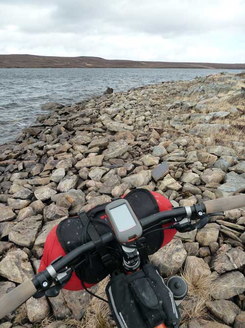
Least there's a causeway on Dubh Loch. Has anyone got any pictures of either Sealga or Dubh?
Mariner wrote: ↑Sun Aug 23, 2020 9:35 am
Following on from a previous thread apparently ATM bypasses Loch Dionard.
See also Rich and Tom Cape Wrath route.
Happy to be wrong, but the ATM routes through Dionard?


Alan Goldsmith at the Loch Na Sealga crossing...oh my

Re: What Going On With The Track Taken From The Highlands;
Posted: Sun Aug 23, 2020 8:17 pm
by ScotRoutes
Re: What Going On With The Track Taken From The Highlands;
Posted: Sun Aug 23, 2020 8:30 pm
by Escape Goat
That looks more appealing.
Re: What Going On With The Track Taken From The Highlands;
Posted: Sun Aug 23, 2020 9:29 pm
by whitestone
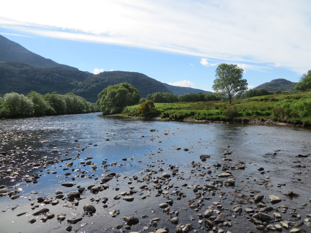
Here's the Strath na Sealga crossing

Here's an aerial shot from geograph.org.uk
Re: What Going On With The Track Taken From The Highlands;
Posted: Sun Aug 23, 2020 10:21 pm
by Mariner
See
viewtopic.php?f=10&t=17570&p=223887&hil ... rd#p223887
My gpx which I created from Glasgow Central Station to CW using the ATM daily ride description and my own research goes via Loch Dionard. The 'new' ATM route to the east appears to have much more road riding. If ever I was in a position to do it I would use the Loch Dionard route or from Sandwood Bay but that is a whole different world of hab.
Re: What Going On With The Track Taken From The Highlands;
Posted: Sun Aug 23, 2020 10:31 pm
by Richpips
Cashel Dhu, looked like nowt though we couldn’t be arseed getting wet feet. Bridget and Joe did it the other day. Strath na Sealga if it is dry looks far more intimidating on the map than it is in real life.
Re: What Going On With The Track Taken From The Highlands;
Posted: Sun Aug 23, 2020 10:32 pm
by sean_iow

That's as deep as the Strath na Sealga crossing got in 2018.
Re: What Going On With The Track Taken From The Highlands;
Posted: Sun Aug 23, 2020 11:28 pm
by Dean
Bearbonesnorm wrote: ↑Sun Aug 23, 2020 9:44 am
On the HT550 there's a bit round a loch (forgotten the name) late on the first or early on the second day - it goes past the haunted house. It's a pain pushing and carrying the bike over the rocks but it's over soon enough.
The water was so low by the haunted house in September 2019 I rode the entire beach without walking (I did bump over a few bigger rocks with a dab or two but it was mostly sand and small gravel). I guess this shows don't expect water levels in Scotland to be consistent.
Re: What Going On With The Track Taken From The Highlands;
Posted: Mon Aug 24, 2020 1:13 pm
by fatbikephil
Aye Cashel dhu is OK under normal circumstances.
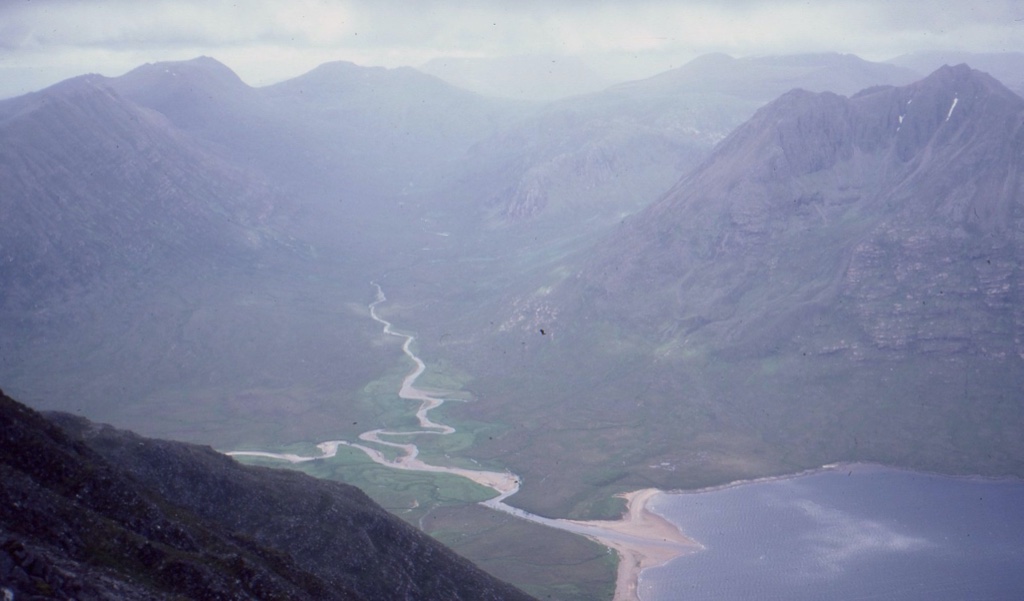
Strath sealga in 2017 -

It was probably at its worst in 2015 and only came to my hips - that said I was about 10m off line which I now know is enough to make quite a difference depthwise - on line it would have only been thigh deep but the waves were much worse
. You'll be fine Allan!
Re: What Going On With The Track Taken From The Highlands;
Posted: Mon Aug 24, 2020 4:53 pm
by Mart
I’ve crossed the Strath na Sealga twice
- first time barely ankle deep
- second time last year it was above the waist
Depth depends on the amount of rainfall
Can be crossed in most states
Re: What Going On With The Track Taken From The Highlands;
Posted: Mon Aug 24, 2020 5:10 pm
by whitestone
Before the start of the 2017 HT550 I asked Ian Fitz about the Abhainn na Sealga crossing as I'm not exactly happy in water and was worried about it. He said he'd only done it in low water but to ask Jenny (Graham). It just so happened I was riding with Jenny after the start and she reckoned it started to drop about two hours after the rain had stopped. So it rises and falls pretty quickly.
In the end it was pretty mild as seen by the photos.
I'd say most rivers that have reasonable ingress/egress will be in a white water kayaking guide either paper or online which will indicate how quickly the river rises and falls after rainfall.
Re: What Going On With The Track Taken From The Highlands;
Posted: Tue Aug 25, 2020 7:35 am
by Escape Goat
Thanks all, that helped out hugely.
Gotta love a bit of line drawing.