
I'm very much an eight hours sleep a night person so two nights in a row of only six hours sleep before setting off should have seen me feeling a wee bit tired but the excitement of this trip outweighed it and I felt good. The start at Jedburgh was an hour and a half drive away which passed quickly enough. After unloading the bike and putting the gear on it my wife says "where's your helmet?". Oh bugger, my helmet and gloves are back home in Edinburgh. My wife suggested checking to see if Jedburgh had a bike shop that opened on a sunday and then wait for it to open which would probably be a least 10am, an hour and a half. If I had waited I would most definitely not make Moffat to catch the chippy that night which I had convinced myself I needed to do in order to refuel and carry on riding to reach Overpawhope bothy where I planned on staying the first night. I knew there was a bike shop at Innerleithen that opened sundays so decided to ride the first 40 miles helmetless. This of course meant riding fast downhills slowly and walking stuff I would normally ride.
The first 30 miles were over farmland with a pleasant and easy ride along the River Teviot and only a few hills. I was following the Borders Abbeys Way and before long arrived at Selkirk. Now came some proper hills as I picked up the Southern Upland Way for 10 miles to Innerleithan. The tracks where dry and fast and I was really enjoying myself despite having to curb my speed.
At Innerleithan the bike shop was open but the cheapest helmet was £40, I had no choice so bought it. The cheapest gloves £28! forget it, i'll manage without. Knowing there would be no more shops until Moffat 40 miles away I bought 2 bananas, 2 apples and 2 pasties to carry with me and ate 2 macaroni cheese pies washed down with coop chocolate milk (the best).
On leaving Innerleithan I once more picked up the Southern Upland Way which took me into the hills again before dropping down to do a circumnavigation of St Marys Loch.
I should point out that the weather was hot with high humidity and very little wind so I was sweating buckets. I was carrying a 750ml water bottle which I seemed to be filling constantly. I was also dousing my head and back on a regular basis in order to cool down.
A quick spin on road saw me to Megget reservoir and the start of the biggest climb of the route up to Dollar Law, 460m in in 3 1/2 miles. This is mostly on rideable landrover track all the way to the top with the occasional kick up in gradient forcing me to push. It was 8pm when I got to the top and the views were just stunning, with the sun sitting low in the sky the hilltops were picked out in golden light for as far as the eye could see. I was still feeling good after nearly 12 hours and the buzz I got off the descent to Stanhope just made me feel even better. Back on road and heading towards Fruid reservoir and another big climb to take me to the top of The Devil's Beef Tub. I have wanted to ride this for a long time so was really looking forward to it but I was now realizing that I would be riding it in the dark, not something I wanted to do as it is a great natural phenomena being a large depression surrounded by high steep sided hills with the route dropping down into it by way of a track hugging the hillside. I also knew that the climb could be bikehike all the way to the top as satellite images of the route were not promising. It was now dark so time for lights, there was no track that I could find, the nature of the terrain very quickly led to type 3 fun, I was not going to make Moffat before the chippy shut, I had no phone signal to call the wife (she worries......a lot), my cycle computer told me I had done 78 miles, the bothy was supposed to be at 90 miles according to bikehike but in reality was more like 115 ( I guess the amount of climbing/descending added about +20% to the distance rather than the usual 10%). I decided to keep climbing until I got a phone signal so I could at least ring my wife. After another 2 miles of type 3 fun/cursing I got a signal so rang home. As I knew I would not make the chippy now and I really wanted to see The Devil's Beeftub I decided to call it a day. I still had two pasties left so supper was sorted. This is the first time I have not taken a tarp and on waking in the middle of the night I got a great view of the stars.
I woke at 5.30 to low cloud and very poor visibilty, no more than 30m. I was away by 6 after a protein bar for breakfast but the low cloud also stopped my phone from getting a gps signal (I was navigating with it using viewranger) and there was no track to speak of. I was navigating blind and going on instinct. Very occasionally you would get a distinct quad bike track only for it to disappear after a few metres. All this led to me making the biggest navigational error I have ever made in my life. I was sure I was headed in the right direction and as the cloud started to lift I was positive I was just below the ridgeline of The Devil's Beeftub but as I crested the final climb I knew I was not where I should have been. The cloud was clearing quickly now and my phone gps picked up a signal. After two and a half hours of type three fun i was a mile and a half off course and heading off at 90 degrees to where I should have been going. I couldn't believe it. I was famished and no way was I going back through what I had just covered only to have to do another two and a half miles of the same stuff. I checked the map, another half mile of bikehike would drop me into a valley with a farm track which led to a road which takes you to Moffat. This is a route test ride I told myself, I can live with this deviation telling myself i'd be back to do it properly, i was gutted at not doing the track down through The Devil's Beeftub though. I got to Moffat at 10am, twelve miles in four hours, my overall speed had dropped from 6.9mph to 3.9mph! Whilst devouring a huge full breakfast with lots of tea I was trying to work out where I had gone wrong and came to the conclusion that I had turned to contour a hill half a mile before I should have, funnily enough the terrain I was then crossing still fitted in with the route on the map. Just goes to show that distances over very difficult terrain in poor visibility seem further than they actually are. I really must get myself a decent gps unit.
I stocked up on more apples and bananas which should see me to Newcastelton, the only place after Moffat that I could get food from until the next day. I was once again on the Southern Upland Way part of which took me through a lovely narrow sided ravine, the second time on this trip that would have been worth taking a camera. Just before entering the ravine I spotted two very healthy looking deer which acted in a strange manner I have never seen before. Normally deer just run away putting as much distance between them and you as possible. Not these two, at first they ran directly away from me for about 200m which is what I expected but then they suddenly stopped and started to run straight towards me, then they stopped again and set of in another direction only to stop again, change direction, run, stop, change direction, run. This went on for about two minutes all in an area of about 100 square metres before they finally found a direction that suited them and disappeared over a hill, maybe I wasn't the only scary thing in the vicinity. Not long after this I came across Overpawhope bothy, my mileage read 128 mile, nothing like the 90 miles bikehike said. My detour added maybe 8 miles so + 20% mileage for the terrain would seem about right.
I turned up onto a good forest road, you know, the hardpack gravel type, that should have taken me over to the next valley. I climbed for about a mile and suddenly no forest road. A gap in the trees but very overgrown, no way through. The map showed a double dashed track all the way to the next valley but I have since checked Where's The Path and there is no forest road and no farm track, possibly some sheep tracks but that's it, how could OS maps be so wrong? To say I was pissed off is an understatement, I was behind schedule by quite a bit and had to do more miles than planned. I decided to get to Newcastleton then see how far I could go from there. I took the road round to the next valley then headed into Craik forest. It was another hot day, not as humid as yesterday but still no breeze. There is a Roman road that runs through Craik forest for about six miles, it starts off on forest road, then good double track and finally a good hardpack singletrack as it climbs. Unfortunately some twit has planted a continuous line of young conifers along both sides which encroach onto the track and the needles on the branches are painfull to push past and also inflict cuts to arms and legs. The track had right of way signs which I wrongly assumed was for the Roman road all the way to the top at which point it goes off to the right so off I went downhill which is what I was expecting. A tee junction at the bottom I was not expecting. Check the GPS and you guessed it, I'm off course again. It is now 5.30 pm and I am way behind schedule, I have spent money on that helmet I am supposed to using for The Wickerman Festival this weekend, if I continue on I will be out for four days rather than three spending more money I don't have and I am thoroughly pissed off. Physically I feel OK but I decide to scratch. The route needs more work and will be here another day. I decide to ride to Langholm, get some food and find somewhere to sleep. Whilst riding my wife rings and I tell her what's happened and she says she will pick me up tonight. At this point I still feel good and ride the 15 miles to Langholm strongly. After being picked up it's a two hour drive home and I am starting to feel a little under the weather. On getting home at midnight I unpack the bike and get a cool shower. As soon as I am out of the shower I feel cold and start to shiver and feel distinctly unwell so go straight to bed under a warm duvet. I warm up very, very quickly. Off goes the duvet and I lie under a sheet. I feel awful but manage to fall asleep. An hour later I wake up, my pulse rate is up quite markedly, my body is radiating massive amounts of heat, I have headache and a dry mouth that no amount of water satisfies. No doubt about it, I have heatstroke. I wake up my wife who gets me the electric fan, iced water and a damp cloth for my head. This helps and I fall asleep again despite still feeling awful. I wake again an hour later and am worse than before. I consider getting my wife to ring NHS 24 but convince myself I will be OK, how stupid of me. With hindsight I am positive I would have been admitted to hospital, with my medical experience I know they would have inserted a saline drip and taken action to cool my body down. I sleep at last still feeling dreadful. The next day I continue to feel very ill with a high temperature and dry mouth but at least my pulse rate has dropped to near normal. I sleep almost constantly for the next 24 hours and drink lots of water but manage to eat only three scrambled eggs all day. On waking today I feel so much better. I am really glad my wife offered to pick me up as sleeping out that night and getting that ill just does not bear thinking about. I had felt fine all day but looking back a couple of tell tale signs should have warned me that things were not right, passing less and less urine and sweating less as day two wore on despite drinking what I thought was copious amounts of water, something I shall remember for the future.
With a bit more work I think this route could be a little cracker, more like 360 miles than 300 though. I thoroughly enjoyed day one and covered 80 very hilly miles, shame day two didn't work out so well but I still managed a very respectable 70 miles, not bad for a 55 year old who spent half of his life abusing his body with drink, cigarettes and drugs.
Kit wise I took a sleeping bag, bivi bag, sleeping mat, inflatable pillow, tools, tubes, waterproof, bike computer, phone, first aid kit, water filter, 6 energy bars (came back with 2), 6 energy gels (used them all and thought they were great, wish I had taken more), money, cash card, ID.
I really want this route to work and in order to make it viable my wife has offered to drive whilst I do sections at a time then camp overnight, she's a darling.
Borders 300 First Test Run.
Moderators: Bearbonesnorm, Taylor, Chew
-
firedfromthecircus
- Posts: 145
- Joined: Mon Mar 11, 2013 7:35 pm
Re: Borders 300 First Test Run.
'kin'ell! Sounds like a bit of a mission.
It's kind of amazing that in this day and age of gps and google earth etc that you can still only really tell what's on the ground by being on the ground.
So do you think the illness was just caused by dehydration or something more? You say you were filling your bottle a lot. From where and with what?
Re: Borders 300 First Test Run.
I have added an edit to say I had heat stroke which I forgot to say in the original draft, it is definitely what was wrong as i have suffered from it before. Used a water filter every time.
Re: Borders 300 First Test Run.
Thanks for sharing that Ray and Im glad your OK.
-
fatbikephil

- Posts: 6538
- Joined: Wed Apr 02, 2014 10:51 pm
- Location: Fife
- Contact:
Re: Borders 300 First Test Run.
Post the route up so we can all have a go!
Re: Borders 300 First Test Run.
I've no idea what its like, but i definitely want to visitRay Young wrote:The Devil's Beef Tub
It wouldnt be called adventure if it all went according to plan and at least you have a story to tell
Re: Borders 300 First Test Run.
Despite the setbacks it sounds like you had fun.
i cant wait until im fit enough to ride mileage like that, i struggle massively with 22miles.
Good job, but bad luck with the heatstroke
i cant wait until im fit enough to ride mileage like that, i struggle massively with 22miles.
Good job, but bad luck with the heatstroke
Its a fine line between a cuddle........
And holding her down so she cant get away!

And holding her down so she cant get away!
Re: Borders 300 First Test Run.
Sorry, not until it is finalised. After that it will be available to all.htrider wrote:Post the route up so we can all have a go!
Re: Borders 300 First Test Run.
The Devils Beeftub.Chew wrote:I've no idea what its like, but i definitely want to visitRay Young wrote:The Devil's Beef Tub
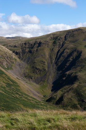 Beef Tub by Al Henderson, on Flick
The track can be seen coming in from the left and runs horizontally to the right where out of shot it drops rapidly to the valley floor. It is a 500 feet deep hollow formed by four steep sided hills. I think you can understand why I want to ride it. So called as The Johnstone Clan who were Border Reivers (cattle thieves and generally bad lads) were known locally as "devils" who would hide their stolen cattle here.
Re: Borders 300 First Test Run.
Thanks for the write-up Ray. Impressive photo. Remember, you can have a lend of my GPS til you get some funds for your own.
Re: Borders 300 First Test Run.
Cracking write up, think we've all been there - although thankfully for me it's only been for short periods of time! Glad you're going to continue with it, interested to see the completed route.
What phone you were using for ViewRanger? I'd have thought that the GPS chip in modern phones would be at least as good as some of the older GPS units. Maybe it's to do with a bigger aerial on the GPS. Anyone know?
Stu.
What phone you were using for ViewRanger? I'd have thought that the GPS chip in modern phones would be at least as good as some of the older GPS units. Maybe it's to do with a bigger aerial on the GPS. Anyone know?
Stu.

Re: Borders 300 First Test Run.
Could be that it's set up to use A-GPS, which takes an approximate position off local mobile network cells first then uses the satellite network to fine-tune it. Phone GPS aerials, as far as I know, are set to prioritise this and subsequently can end up hunting quite badly if there's no mobile signal. Depends on the phone but on some* have the ability to turn off the A-GPS setting which can help.What phone you were using for ViewRanger? I'd have thought that the GPS chip in modern phones would be at least as good as some of the older GPS units. Maybe it's to do with a bigger aerial on the GPS. Anyone know?
*a couple of old ones I used definitely, but can't remember exactly what
"Where you've been is good and gone, all you keep's the getting there..."
Re: Borders 300 First Test Run.
I run mine in Airplane mode if I'm tracking a route while out riding so that should disable A-GPS.
I use a Galaxy S3 and haven't had problems with the GPS failing to connect (including some times in mist), but am interested what benefits a dedicated GPS might give. I'm keen to make sure that if I'm relying on GPS it's not going to fail. Most of the time I have paper maps as backup.
Stu.
I use a Galaxy S3 and haven't had problems with the GPS failing to connect (including some times in mist), but am interested what benefits a dedicated GPS might give. I'm keen to make sure that if I'm relying on GPS it's not going to fail. Most of the time I have paper maps as backup.
Stu.
-
fatbikephil
- Posts: 6538
- Joined: Wed Apr 02, 2014 10:51 pm
- Location: Fife
- Contact:
Re: Borders 300 First Test Run.
No worries - I've pretty much worked it out from your description in anycase - I note the 'missing track' doesn't appear on the 25k maps but it does on the 50k... odd. I guess you'd be able to fight your way through as there are a few lines showing up on the aerial photos and it does miss a fair bit of road work out.Ray Young wrote:Sorry, not until it is finalised. After that it will be available to all.htrider wrote:Post the route up so we can all have a go!
Re: Borders 300 First Test Run.
The phone I have is a Sony xperia miro and I had a similar problem in similar conditions back in the winter. At that time I put it down to my not knowing how to use it properly.
The photo is not mine, I pinched it from flicker and chose the one that best showed off the track.
Thanks for the positive comments.
The photo is not mine, I pinched it from flicker and chose the one that best showed off the track.
Thanks for the positive comments.