Anyone attempted to ride / hike-a-bike the shore of Loch Dionard ( just off the northern tip of the Highland 550).
Do-able? North shore or south shore?
Loch Dionard
Moderators: Bearbonesnorm, Taylor, Chew
-
fatbikephil

- Posts: 6538
- Joined: Wed Apr 02, 2014 10:51 pm
- Location: Fife
- Contact:
Re: Loch Dionard
No, but I know someone who has. Its doable but a bit tricky. He went with the west / south shore which was rough but the river crossing at the head of the loch seemed to be easier than at the foot. Plus if this crossing is impassable, you can fight your way up to the end of the track further up the west side of the burn. On of several 'gaps' I've had my eye on but never found the excuse yet!
Re: Loch Dionard
Thanks. Confirms what I was thinking about the river crossings from looking at satellite pics. Coming up from Glen Golly and heading towards Cape Wrath, having previously suffered over the H550 route over Bealach Horn ( never again) I thought this might make for an interesting alternate.
Just realised I've posted in the wrong forum. Mods please delete/move as required.
Just realised I've posted in the wrong forum. Mods please delete/move as required.
-
whitestone

- Posts: 7863
- Joined: Thu Dec 04, 2014 10:20 am
- Location: Skipton(ish)
- Contact:
Re: Loch Dionard
I thought I'd check the climbing guidebooks since there's some big crags on the north side of Foinaven overlooking Loch Dionard. I don't have the SMC guide to the area but one guidebook I do have states that it's 30mins walk on deer tracks from the end of the track to roughly this point http://streetmap.co.uk/map.srf?X=235619 ... &A=Y&Z=120. Interestingly it also states to "Ignore the no cycling signs, the (estate) track was built and paid for with public money!"
UKClimbing https://www.ukclimbing.com/logbook/crag ... nu_mor-304 doesn't have any notes on how long it takes to get to the crags. To me that 30mins seems somewhat optimistic given that these aren't popular crags so unlikely that there's a well defined path to get there.
Nothing on Geograph showing any tracks. Looking on Google maps the mouth of the Allt an Easain Ghil which comes down from Bealach Horn looks like it has a set of deposition bars similar to those on the Abhainn na Sealga in Fisherfield so could be easy to cross. Actually even the outflow doesn't look too bad -
If you search the forums for "dionard" you'll get a few hits which do discuss things.
Better weight than wisdom, a traveller cannot carry
-
fatbikephil
- Posts: 6538
- Joined: Wed Apr 02, 2014 10:51 pm
- Location: Fife
- Contact:
Re: Loch Dionard
The direct track from Gobernuisgach lodge over to Lone via the Bealach Feithe is much easier than the 'Horn' route - basically a rough landrover / argocat track, albeit over a bit of a bump. I've not done this either but another mate has biked it and taken a few D of E groups this way.woodsmith wrote: ↑Fri Jul 03, 2020 10:23 am Thanks. Confirms what I was thinking about the river crossings from looking at satellite pics. Coming up from Glen Golly and heading towards Cape Wrath, having previously suffered over the H550 route over Bealach Horn ( never again) I thought this might make for an interesting alternate.
Just realised I've posted in the wrong forum. Mods please delete/move as required.
Re: Loch Dionard
Thanks for all the helpful info. Looks like its a possibility once travel restrictions are lifted of course.

Re: Loch Dionard
I was sure RSF had a route up to Cape Wrath using Loch Dionard but cant find anything listed in the archive.
An Turas Mor certainly goes that route and describe that section as the only hab on the route.
In the great scheme of things the Dionard section is relatively short compared to the overall route and it would not be a proper adventure without a hab.
An Turas Mor certainly goes that route and describe that section as the only hab on the route.
In the great scheme of things the Dionard section is relatively short compared to the overall route and it would not be a proper adventure without a hab.
Zazen - nothing happens next this is it.
Re: Loch Dionard
From the track I've seen on RWGPS, An Turas Mor goes from Gobernuisgach Lodge to Cachel Dhu and over to Loch Eribol.Mariner wrote: ↑Sun Jul 05, 2020 9:36 am I was sure RSF had a route up to Cape Wrath using Loch Dionard but cant find anything listed in the archive.
An Turas Mor certainly goes that route and describe that section as the only hab on the route.
In the great scheme of things the Dionard section is relatively short compared to the overall route and it would not be a proper adventure without a hab.
Agree with the HAB sentiment. Its not called a push-bike for nothing.
Re: Loch Dionard
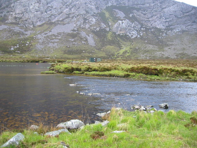
Just as a follow up i did this route on the 31st August in dry weather after a few days with no significant rainfall.
The Glen Golly track after the Highland 550 turnoff continues to climb a little but is 100% rideable. The decent down to Loch Dionard is steep and very loose in places but again 100% rideable. Would probably make for a lot of pushing in the opposite direction ( for me anyway)
Although the river crossing at the southern end on the Loch looks better the western shore looked a much trickier hike-a-bike. Chose to hike the eastern shore and from fishing lodge to fishing lodge it was a fraction over 30minutes of fairly easy pushing. Followed sheep/deer tracks along the shore initially before straight lining to a point well to the east of the fishing hut on the northern end. Shallow (less than hub depth)river crossing and a bit more hike a bike to reach the fishing hut and the track.
Track up to the main road is in generally excellent condition.
Hope this is of help.
-
fatbikephil
- Posts: 6538
- Joined: Wed Apr 02, 2014 10:51 pm
- Location: Fife
- Contact:
Re: Loch Dionard
Nice one - any pics?
It occurs to me to collate a list of such trail notes but I guess it would be quite an undertaking....