Bivyplorer
Moderators: Bearbonesnorm, Taylor, Chew
Re: Bivyplorer
Read this post and signed up for VV, now I'm hooked! Been off bog trotting on the banks of the forth to get a square tonight and now I have a route mapped to grab me another 49 squares, that might have to be my january bivvy.

-
ZeroDarkBivi

- Posts: 1267
- Joined: Fri Jun 27, 2014 9:18 am
- Location: Somerset
Re: Bivyplorer
Have I misunderstood this - is the challenge to do multiple bivis, all within a km or two of the last one? Sounds somewhat repetitive...
-
whitestone

- Posts: 7877
- Joined: Thu Dec 04, 2014 10:20 am
- Location: Skipton(ish)
- Contact:
Re: Bivyplorer
Put like that and if you chose somewhere like Kielder Forest then it could be. You don't have to go back to the same area time and again, there's no time limit and you can use the locations of previous bivvies to put something in the bank as it were. The challenge is to see more bivy potential in the countryside so you aren't relying on "that spot", going for contiguous squares just puts a structure on it.ZeroDarkBivi wrote:Have I misunderstood this - is the challenge to do multiple bivis, all within a km or two of the last one? Sounds somewhat repetitive...
Better weight than wisdom, a traveller cannot carry

Re: Bivyplorer
I like the idea of the bivyplorer. If the idea of using the 1km x 1km grid squares doesn't appeal then how about the larger grids? From the OS website..
"The National Grid breaks Great Britain down into progressively smaller squares identified first by letters and then numbers.
The largest unit of the grid is 500km squares each designated by a prefix letter alphabetically from A-Z omitting I - the first letter to be quoted in today's National Grid Reference. Great Britain is covered only by four of these squares: H, N, S and T.
The 500km squares are then further broken down in to twenty-five 100km squares which are identified by a letter, again A - Z omitting I ( the second letter quoted in a reference).
These squares are divided into smaller squares by grid lines representing 10 km spacing each numbered 0 - 9, from the south-west corner in an easterly and northerly direction. You can thus identify a 10km grid square by quoting two grid letters and the eastings and northings; for example, TQ 6 3.
On OS Landranger Maps, you will find the two grid letters on the legend or the corner of the map. The 10km grid is then further broken down into 1km grid squares"
So you could pick any size of grid and work with that. How about the four main 500x500km for a start? Assuming you don't live near the intersection of the four that would require some travelling to tick off those.
Where I live (Isle of Wight) doesn't lend itself to the 1kmx1km squares as there's too much development/private land so some squares are all private garden. I think I'm going with my original miss-interpretation and use the 10km x 10km grid and try and tick all of them off which is 11 for the whole Island. I think the idea is a great one and I would never of though of it without this thread. It will force me to look for new spots. I'm looking forward to 11 bivis in new places throughout the year Perhaps once I've finished the Island I'll have to start on the mainland ones within riding distance of the ferry routes.
"The National Grid breaks Great Britain down into progressively smaller squares identified first by letters and then numbers.
The largest unit of the grid is 500km squares each designated by a prefix letter alphabetically from A-Z omitting I - the first letter to be quoted in today's National Grid Reference. Great Britain is covered only by four of these squares: H, N, S and T.
The 500km squares are then further broken down in to twenty-five 100km squares which are identified by a letter, again A - Z omitting I ( the second letter quoted in a reference).
These squares are divided into smaller squares by grid lines representing 10 km spacing each numbered 0 - 9, from the south-west corner in an easterly and northerly direction. You can thus identify a 10km grid square by quoting two grid letters and the eastings and northings; for example, TQ 6 3.
On OS Landranger Maps, you will find the two grid letters on the legend or the corner of the map. The 10km grid is then further broken down into 1km grid squares"
So you could pick any size of grid and work with that. How about the four main 500x500km for a start? Assuming you don't live near the intersection of the four that would require some travelling to tick off those.
Where I live (Isle of Wight) doesn't lend itself to the 1kmx1km squares as there's too much development/private land so some squares are all private garden. I think I'm going with my original miss-interpretation and use the 10km x 10km grid and try and tick all of them off which is 11 for the whole Island. I think the idea is a great one and I would never of though of it without this thread. It will force me to look for new spots. I'm looking forward to 11 bivis in new places throughout the year
Adventure without risk is Disneyland - Bikemonger

Re: Bivyplorer
Well thanks to this thread I've just signed up to Veloviewer
It's like crack for geeks isn't it?
I'm loving the Explorer score, I'm trying to work out how I can hit a few more squares by extending my commutes... I'm at 9x9, I reckon I can get to 11x11 without a huge amount of drama
It's like crack for geeks isn't it?
I'm loving the Explorer score, I'm trying to work out how I can hit a few more squares by extending my commutes... I'm at 9x9, I reckon I can get to 11x11 without a huge amount of drama
Re: Bivyplorer
Does anyone know if there is a way to print the explorer map off? I'm scrolling around in it, but my geekery thermometer will attain new heights if I could print it out and draw/highlight it
-
whitestone
- Posts: 7877
- Joined: Thu Dec 04, 2014 10:20 am
- Location: Skipton(ish)
- Contact:
Re: Bivyplorer
Geek central isn't it 
What I find surprising is, even in relatively rural areas, just how few squares are left once you've ridden all the roads in the area. Add in the bridleways and there's very little left to leave for cheeky rides.
I've got 3 instances of 8x8 Explorer scores, just got a few odd square here and there to link them up. After that I'm limited north and west by some very anti-access (of any kind) estates so there'll be quite a bit of urban riding involved.
Printing the Explorer map: You could do a screen grab, on a Mac something like Grabit would do the job.
Better weight than wisdom, a traveller cannot carry
Re: Bivyplorer
There's a veloviewer extension for chrome that overlays the explorer tiles on the strava route builder. 
http://blog.veloviewer.com/veloviewer-c ... a-website/
Currently on 17x17, might get to 18 or 19 soon but I'm moving house in the next few months and will need to start all over again.
http://blog.veloviewer.com/veloviewer-c ... a-website/
Currently on 17x17, might get to 18 or 19 soon but I'm moving house in the next few months and will need to start all over again.
Re: Bivyplorer
Here's mine
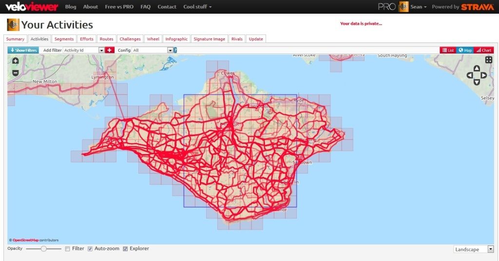
Is the darker blue square the max square? This looks like it's 10x10 but my summary page only shows 8x8 as the max square size?
Slightly academic as increasing the size is not possible due to my location unless I charter a boat and ride around in circles on deck whist sailing around the Island
Is the darker blue square the max square? This looks like it's 10x10 but my summary page only shows 8x8 as the max square size?
Slightly academic as increasing the size is not possible due to my location unless I charter a boat and ride around in circles on deck whist sailing around the Island
Adventure without risk is Disneyland - Bikemonger
Re: Bivyplorer
Bob, thanks. Currently print screening into powerpoint
Going to check out that chrome link
Sean, pretty sure it is - mine is 8x8 and shows up as 8x8
Going to check out that chrome link
Sean, pretty sure it is - mine is 8x8 and shows up as 8x8
-
ScotRoutes
- Posts: 8144
- Joined: Mon Mar 18, 2013 9:56 am
Re: Bivyplorer
There's rural and there's ruralwhitestone wrote:What I find surprising is, even in relatively rural areas, just how few squares are left once you've ridden all the roads in the area. Add in the bridleways and there's very little left to leave for cheeky rides.
Re: Bivyplorer
I've worked it out the reason for the difference between score and map. The summary page is for rides (8x8) but the map above includes runs. If I change the config to just rides I get an 8x8 blue square max size. I've spotted that there is one square I've not ridden through, no roads but it is Forestry Commission so gravel tracks available. Looks like I'll be riding to work on the mountain bike tomorrow to get the missing square on the way home and my score should then go up to 10x10sean_iow wrote:Here's mine
Is the darker blue square the max square? This looks like it's 10x10 but my summary page only shows 8x8 as the max square size?
There is also snow forecast for tomorrow (I'll beleive it when I see it) so the mountain bike might be a better choice anyway rather than the usual road bike.
Adventure without risk is Disneyland - Bikemonger
-
ScotRoutes
- Posts: 8144
- Joined: Mon Mar 18, 2013 9:56 am
Re: Bivyplorer
Ah yes, my Explorer square includes all activities (by necessity really).
Time to buy yourself a packraft
Time to buy yourself a packraft