The issue is that the route as originally conceived has a significant section that is closed due to severe erosion. This could remain the case for up to 18 months, and as yet repair work has not commenced. It happens to be a key part of the route that doesn't have any suitable alternative to maintain the total distance of 100 miles. There have been a few other sections where harvesting is taking place that would limit access at certain times.
The sign says closed to all traffic. You could lift your bike over the locked gates if you want, but I don't want to appear to be encouraging anyone to do that by distributing the GPX for it.
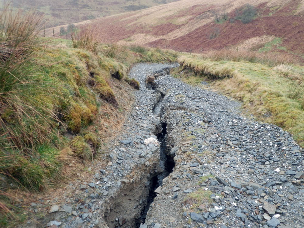
There is a safety issue too. The erosion gully is over 5 feet deep and would need crossed several times to get to the bottom.
Ian wrote:The sign says closed to all traffic. You could lift your bike over the locked gates if you want, but I don't want to appear to be encouraging anyone to do that by distributing the GPX for it.
There is a safety issue too. The erosion gully is over 5 feet deep and would need crossed several times to get to the bottom.
WOW OK when I went through last the gates weren't locked and there was just a laminated paper sign saying something about 4x4s, it was a little while ago now though. The gully is pretty outrageous though. There was one point I had to cross it and it was too wide to step with a loaded bike. I had to jump down into it and lift the bike across then climb out the other side!
the photo Neil posted is between Soar y Mynydd and Tyn' y cornel hostel iirc. I was planning in the week before BB200 to do the 200 mile gravel route over 3 days stopping at 2 bothies for a nice 3 day trip (Nantsyddion and Moel Prysgau).
I am happy to omit this section if OOB for now and can 4 see options:
1) Before the chapel turn West / SW past Nany IIwyd into Doethie Valley and then ride NE to hostel to rejoin route.
2) Reroute to climb Doethie Valley from the bottom all the way up to the hostel to rejoin route
3) Instead of all Doethie Valley ride NE up possible(?) vague bridelway past Bryn Ambor and then join road to rejoin route at 723527.
4) Continue N on road past chapel to join route (as per old BB200 course) for about 5km.
Which would you suggest. Any other areas I should aim to avoid? Or am I better advised to look at a completely different route?
The road closure extends to the ford crossing about 1/2 mile east of the hostel. The Doethie option still brings you out into the badly eroded bit. Option 4 is your best bet for now.
I don't know the 'Gravel' routes so this may be bollox and miles from where you need to be (!) but I have ridden (albeit some years ago) from 756459 N/NW to 737516. It was boggy along the (SW) edge of the forest plantation but passable, the rest was all rideable.
(I also tried to continue to 755532 but failed, losing the route through the woods and attempting to fight my way through overgrown ditches. There was probably a perfectly good route within a few yards of me but I'll be damned if I could find it!!)
We go out into the hills to lose ourselves, not to get lost. You are only lost if you need to be somewhere else and if you really need to be somewhere else then you're probably in the wrong place to begin with.
Any idea on the closures and if they are now lifted or if they are planning to open then before May's WRT as I'm "thinking" of doing this from the WRT weekend as part of my training towards the Dales 300
As I remember it there are some serious drainage issues that had to be sorted before the trail was going to be repaired and reopened. Personally I doubt it has been officially reopened.
In all honesty it being closed is not really something I would personally worry about. Bare in mind though I will pretty much ride any track in mid Wales, ROW or not.
Any idea on the closures and if they are now lifted or if they are planning to open then before May's WRT as I'm "thinking" of doing this from the WRT weekend as part of my training towards the Dales 300
Why not simply use the WRT grid references to form a route ... training or otherwise?
Or I could supply you with last years BB200 route if you'd like some proper training
s8tannorm wrote:
Why not simply use the WRT grid references to form a route ... training or otherwise?
Or I could supply you with last years BB200 route if you'd like some proper training
Of course I'll look at the grid refs but the Dales 300 is mainly bridleways and gravel roads and shouldn't have the bog slogs that you will put in or the death marches of the BB200 ;-)
Of course I'll look at the grid refs but the Dales 300 is mainly bridleways and gravel roads and shouldn't have the bog slogs that you will put in or the death marches of the BB200 ;-)
Has anyone done the ton of gravel route in 2015? I am considering it sometime between 22-25 Jan (spare 2015 hols I need to use up in Jan).
I heard about the erosion / mega gully at the 'Pre Doethie drop' segment and I read the comments above. But I wonder if the road is now repaired, because I noticed (ie, Strava stalked) these guys that rode it in October 2015?
In short, I don't know as I've not been by for quite some time. The closure order was set for the maximum duration of 18 months, by which time they should/ had to have fixed it. I think the 18 months was up in May 2015, but who knows whether they actually fixed it
You could try ringing Ceredigion County Council. Wendy Campion is the rights of way officer for that part, iirc.
composite wrote:As I remember it there are some serious drainage issues that had to be sorted before the trail was going to be repaired and reopened. Personally I doubt it has been officially reopened.
This road has been repaired and there are no signs of closure. Andy and I rode it going East from the reservoir towards Tyn cornel hostel and the descent is fine now. Hope this helps someone! ;-)
Ha, I went over it today too, and was going to post the same
They seem to have done a decent job - occasional water channels across the path, but not square edged so you can roll through nice and easy. At the moment it's not st all rutted, so it'd be dead quick to the bottom just now if you've got the nerve.


